Looking for some of the best hiking in Moorea? No need to look further!
Moorea is an island that satisfies all types of tourists. Whether you just want to relax and soak in views or you’re an adventure seeker always ready for excitement, this island has something for everyone.
When you arrive in Moorea, the first thing that could leave you absolutely amazed is its mountains. You’d see many lush jagged mountains attracting tourists for a hiking adventure.
There are a variety of trails in Moorea, some trails are short and easy to complete, perfect for those looking for quick in and out. But there are also some trails that are more challenging and require courage to complete them, definitely for experienced hikers.
This blog post will guide you through the best hikes in Moorea. You’ll learn about different trails, know which trail is for you, and what to expect during your trekking journey.
Top Hiking Trails in Moorea
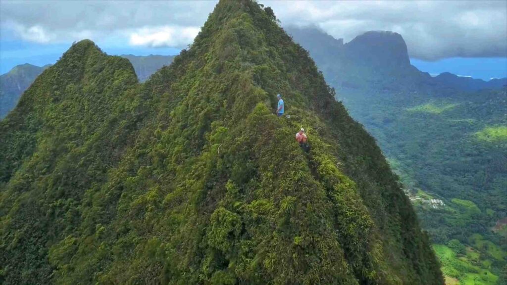
1. Mount Rotui Hike
- Length: 4.2 miles
- Difficulty: Demanding
- Elevation: 900 meters
Mount Rotui Hike is one of the most challenging hikes in Moorea due to its steep and rugged path. It’s a 4.2 mile long hike that could take you around 6 hours to go out and back.
Mount Rotui is the second tallest mountain in Moorea reaching a height of 900 meters (2950 feet). It is located between Opunohu Bay and Cook’s Bay on the northern side of the island.
There was a report of an American death due to falling when he tried to summit Mount Rotui in 2022. Back in the 2000s, a group from Texas also tragically lost their lives while trying to conquer the peak.
Getting to Mount Rotui is easy, there are several points from where you can get to Mont Rotui. The most frequently used one is located near the Hilton Moorea, opposite side of the road. You’d need to walk down the driveway until you see a sign “Rotui” that will point you to the trailhead.
The trail starts out fine, looks easy, but as you go up and higher, it gets harder and harder and you start questioning whether you should do it or not.
Some people do stop the hike halfway, and that’s perfectly fine. I’d also suggest that if the trail feels difficult to you, feel no pressure to head up the mountain.
Although the trail is surrounded by lots of overgrown plants, there isn’t much shade available, you’ll be sweating buckets if the sky’s clear. Additionally, the trail is narrow and a bit slippery and gets even more slippery after the rain. So it’s advisable to hike Mount Rotui when the trail is dry and the weather is favorable.
Once you reach the top, you are presented with incredible views of Moorea. The views of both bays from the top are truly spectacular.
While this may be a difficult hike, it offers a breathtaking and scenic hiking experience for those who are willing to take the challenge.
2. Three Coconuts Trail (Col des Trois Cocotiers)
- Length: 4 miles
- Difficulty: Moderate
- Elevation: 390 meters
Three Coconuts Trail also known as Three Coco Pass is a popular trail that starts from the Belvedere Lookout. It’s a 4 mile long hike that gains an elevation of 390 meters. It usually takes around 3 hours to complete this trail from the Lookout point.
To reach the trailhead, you need to get to the Belvedere Lookout parking area, look for the sign “Col des 3 cocotiers” and start your hike from there.
The trail is not too difficult, most hikers enjoy trekking on this trail. However, some individuals might find it a bit challenging due to its moderate difficulty level.
There are lots of rocks and tree roots on the trail that make it slippery and a bit tricky to navigate. The good thing is that the trail is well-shaded by the jungle canopy, so you’re protected from the hot sun.
Even though the temperature doesn’t soar too high here due to the jungle, the downside is that the abundance of surrounding foliage restricts the airflow, resulting in a stuffy & humid environment that can make you sweat a lot.
You’d notice blue and orange marks on the trail, I’d suggest taking the blue trail and ignoring the orange one as it gets longer and harder than the blue one.
While on your way up, there are many points where you can take a few-minute break and enjoy the amazing views of Opunohu and Cook’s Bay. And the views from the top just get better.
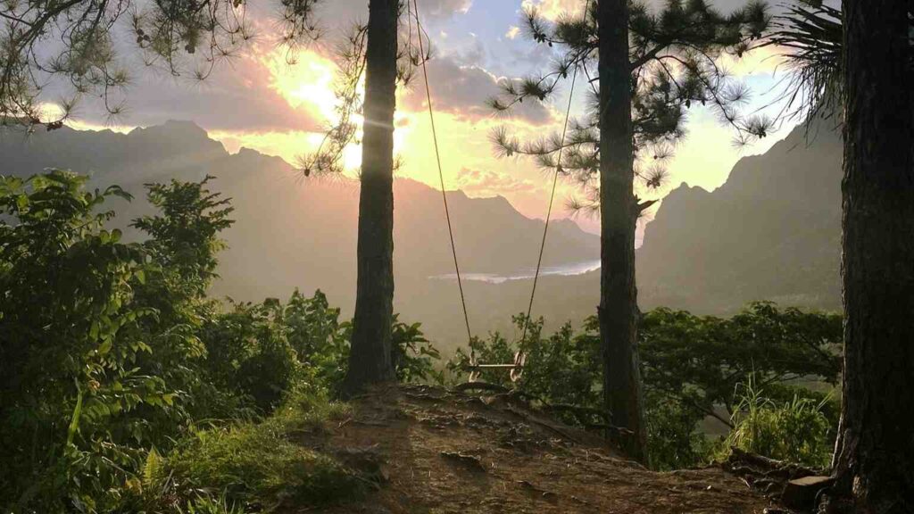
3. Three Pines Trail (Col des Trois Pinus)
- Length: 2 miles
- Difficulty: Easy
- Elevation: 309 meters
If you’re an inexperienced hiker and thinking about short and easy hiking in Moorea, then the Three Pines Trail is for you.
Three Pines Trail also referred to as Three Pines Pass is a 2 mile long trail that is relatively easy to hike. It starts at the Belvedere Lookout Point parking area and usually takes about 1 hour and 30 minutes to go out and back, and gets to a height of 309 meters.
In order to get to the trail, head over to the Belvedere Lookout parking area. There you’ll need to find the sign that says “Col des 3 pinus”, this is where your Moorea hiking journey begins leading you into the jungle.
At the start, the trail looks flat and easy, but it gets pretty steep and rough near the end. The trail is easy to follow since it’s well-marked and doesn’t get complicated along the way.
The temperature there remains moderate because of the nice shade from the tropical trees, but be prepared to get sweaty due to the heat and humidity. The trail is a bit slippery and also gets muddy after the rain, so if this happens in your case, consider wearing mud shoes.
At the end of the trail, you not only have stunning views but also there’s a swing waiting for you, which is a fun and unexpected surprise.
4. Afareaitu Waterfalls
- Length: 1 miles
- Difficulty: Easy-Moderate
- Elevation: 240 meters
Afareaitu Waterfalls is a great spot for those looking for a short outdoor adventure. Hike to the waterfalls is not too difficult, it’s a one mile long trail that would take you around 30 minutes to reach the waterfalls.
The waterfalls are situated at an elevation of 240m in the village of Afareaitu in the southeast of Moorea.
Reaching the Afareaitu waterfalls is simple, you can follow the map that can take you to a small parking area, where you might have to pay $2 for parking. Or you can park a little before this near the school where the parking area is big and there’s no fee.
The trail is a bit rough and rocky and gets slippery in the rainy season, I’d recommend wearing hiking shoes on this Moorea trail. Keep in mind that there could be mosquitos and fire ants, so a bug spray would definitely be helpful.
The good thing is the trail is well shaded by tropical trees but the humidity might still make you sweat. Don’t worry, if you’re feeling hot, you can cool off with a refreshing swim at the waterfall in the end.
You’ll come across two waterfalls on this hike, first one is small, while the second one is quite high about 100m and is the main attraction point.
5. Magic Mountain Hike
- Length: 2 miles
- Difficulty: Easy
- Elevation: 181 meters
The hike to the Magic Mountain is quite easy but don’t take it as a stroll in the park. It’s a 2 mile long hike that usually takes about 30 minutes to reach the mountain top, which stands at a height of 181 meters.
Magic Mountain is a lookout point in Moorea that is famous for its breathtaking views of Opunohu Bay. It is located on the north of the island near Ta’ahiamanu Beach in Papetoai.
You’ll be asked to pay $2 per person at the parking area before you start the mountain hike. This is probably the only hiking spot in Moorea where you’ve to pay.
After paying that, look for the “Montagne Magique” sign or ask a local if you don’t know your way. There are two routes that get you to the Magic Mountain, one on the left is easy and less steep than the one on the right.
If for some reason you don’t wanna walk, you can also go up the magic mountain by taking an ATV tour.
The trail is mostly shady and nicely paved, although there are some parts that aren’t so even or shaded. If you go out on a hot day, you’ll definitely be drenched in sweat, so maybe go in the morning or afternoon.
Once you’re up at the lookout point, you get the panoramic views of the northern side of the island and Opunohu Bay which are well worth the hike.
This hike is suitable for people with decent physiques and is also great for kids. If you’ve got kids, bring them with you.
6. Mount Mou’aputa (Pierced Mountain)
- Length: 4.5 miles
- Difficulty: Demanding
- Elevation: 830 meters
If you’re considering hiking Mount Mou’aputa, it’s important to know that this is a really hard hike. It’s definitely not recommended for families and individuals who aren’t physically fit or have a fear of heights.
Mount Mouaputa is the 4th highest mountain in Moorea with an altitude of 830 meters. It’s about 2.8 km away from Mount Rotui situated in Paopao village north of the island.
The Mou’aputa hike is approximately 4.5 miles in length which usually takes around 4 hours to complete. This hike mostly involves climbing uphill with a few switchbacks along the way.
The trail starts with a steep and rough path, then it flattens out a bit at the river. If your goal isn’t the waterfall, make sure to turn left after crossing the river. Afterward, the trail gets steep again and becomes more challenging as you continue your ascent.
There are some sections that are so steep, even if the ground is dry, there’s a risk of slipping (don’t worry, it’s not life-threatening slippery). To help with this, there are ropes available that you can hold onto while you continue climbing.
Moreover, there’s lots of overgrown foliage but don’t expect much shade on the trail.
The views from the top ridge are absolutely breathtaking! You’ll be able to see Mount Rotui, both bays and a 360-degree view of the island.
This hike in Moorea is not recommended during or after rain, but you can still do it at your own risk. Additionally, having a guide along can make it a somewhat easier and enhanced experience.
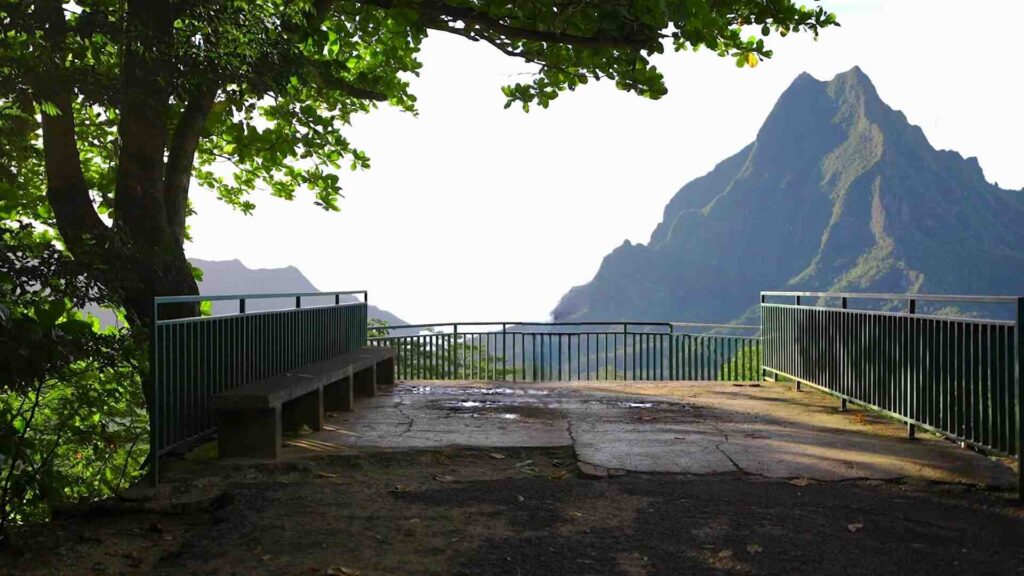
7. Belvedere Lookout
- Length: Vary
- Difficulty: Moderate
- Elevation: 250 meters
While most people choose to drive to the lookout, a hike to the Belvedere Lookout is also a great option to get to this viewpoint.
This is a moderate hike and could become longer and more challenging based on your starting point. There are many ways to reach Belvedere, but the most common route is the 3 Coconut Trail (Col des 3 Cocotiers).
To start the hike, head over to Opunohu Bay road and park your car at the bottom of the hill. You wouldn’t find any trail marks since this isn’t an official Moorea hiking point. Instead, you’ll need to look out for a dirt path leading you through the jungle, and at some point you’ll reach the Coconut Trail.
The trail can get steep, rocky and slippery at some parts, but don’t worry, overall it’s not that hard. You’ll be mostly walking through the jungle, so lots of shade there to keep you cool, but you’d still be sweating because of the humid environment.
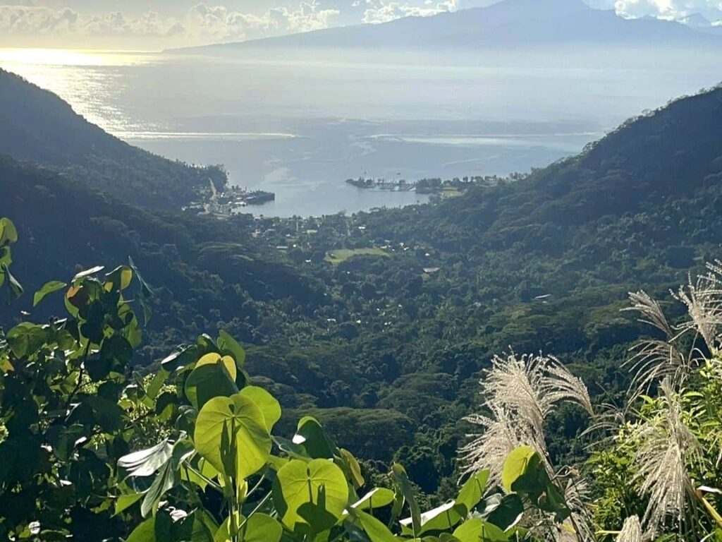
Once you reach the Belvedere Lookout point after a 2 – 3 hour hike, you get the stunning views of both bays and Mount Rotui.
You can take it up a notch and keep hiking higher, as there are several trails that begin from the Lookout point, offering more adventure.
8. Vaiare Pass (Col de Vai’are)
- Length: 2.9 miles
- Difficulty: Moderate
- Elevation: 326 meters
The Vai’are Hike is a relatively short and easy trail, but it does get a bit more difficult towards the end. It’s a 2.9 mile long hike that usually takes more than an hour to complete it. Hiking on this trail will take you to an elevation of 326 meters at Col de Vai’are (Vai’are pass).
In order to get to the trail starting point, make your way to the Vai’are village and look for the trail sign opposite the market. If you’re coming from Tahiti on a ferry, you’ll arrive at Vaiare Port in Moorea, and the trailhead is just a short walk away from there.
The trail kicks out fine, looks easy and straightforward but as you move forward, it starts getting harder. The second half is where the trail gets really steep and challenging, consuming most of your time and effort.
In general, you’ll find this trail rocky and slippery, much like any trail in Moorea. You’d mostly be walking under the shade but you do get exposed near the end.
The vistas from above are absolutely amazing, you can see Mount Mou’aputa and the beautiful landscape of Moorea. On the East, you’ll have a view of Bay Vaiare and to the north, you’ve the Cook’s Bay.
9. Vai’are to Paopao
- Length: 7 miles
- Difficulty: Hard
- Elevation: 326 meters
Vai’are to Paopao hike is about 7 miles in length and would take you more than 5 hours to complete this trail. The hike’s highest elevation gain is around 326 meters.
This hike is very similar to the one described above, following the same path until reaching the Col. It’s basically an extended version of the Col de Vaiare trail that leads further toward the Paopao village.
Vai’are to Paopao hike is not too difficult but its distance is what makes most people scramble. While the beginning and end of the hike are relatively easy, it does get a bit more challenging as you near the Col at the top.
There are some sections that get steeper, so ropes are there to help with that. The trail is mostly shaded by a lush canopy of tropical forest though you do get exposed near the top.
Whether you descend at Vaiare or Paopao, the views on both sides are amazing. On the Vaiare side, you’ll see Vaiare Bay and the eastern part of Moorea. On the Paopao side, you can enjoy the sights of Cook’s Bay, Mount Rotui, and the northern part of Moorea.
You can start your hike either from Vai’are near the Bayside Market or start from Paopao near the school.
10. Paaruiti (Mount Paaru Iti)
- Length: 3 miles
- Difficulty: Hard
- Elevation: 642 meters
Paaruiti is a hike that can be described as both easy and hard in terms of difficulty. Let me break it down for you, the first one-third of the hike is relatively easy, while the rest gets quite challenging as you ascend towards the top.
Finding the Paaruiti trailhead might seem a bit tricky, but it’s actually quite simple. It’s located right to the post office building, just a few minutes walk away from the Sofitel Moorea Resort in Te’avaro village.
First Lookout
The initial one-third of the trail takes you to the first hill where the flag is. If you’re looking for a quick in-and-out hike, then this is your turnaround point.
The trail leading up to the flag is pretty straightforward. The path is a bit steep, slippery but is mostly clear. It’s around a mile-long trail that would take you less than an hour to reach the lookout point.
There you’ve stunning views of Moorea lagoons and peaks, you can even catch a glimpse of the mountains of Tahiti calling for hiking adventures.
Hike up until this point is suitable for families and those in reasonably good shape.
To the summit
The second part of the trail really challenges your hiking skills as it gets steeper and rougher. At some sections, you’ve got some ropes hanging around to give you a hand in climbing up.
The trail is mostly exposed and the sun can get pretty fierce during the day, so it’s best to schedule your hike in the morning, evening or when there’s some cloud to protect you.
Additionally, the trail can be quite overgrown, consider wearing long pants/sleeves if don’t want yourself to get scratched up.
It’d take you approx. two more hours from the flag point to reach the summit, making it a 3 miles roundtrip from the starting point. When you reach the top, the views become even more awesome compared to the flag point.
This is one of those Moorea hikes that can’t be recommended in rainy conditions.
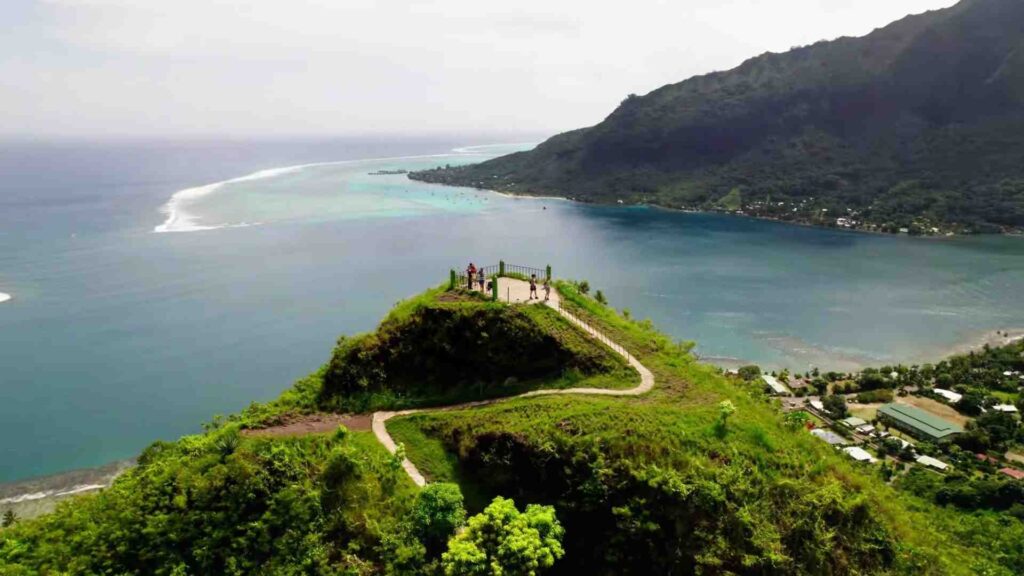
11. Toatea Lookout
- Length: Vary
- Difficulty: Easy
- Elevation: 61 meters
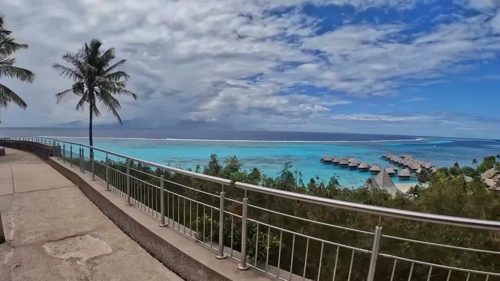
Toatea Lookout is a viewpoint that showcases the beautiful blue waters of Moorea, the lush tropical trees and you can also see Sofitel Overwater Bungalows from this spot.
The Lookout point is located near the main road on the eastern side of Moorea.
Since Toatea Lookout isn’t an official hiking spot, you wouldn’t find any trail marks or a designated path leading to the viewpoint. So you’re free to start your hike from any point, but I recommend starting at the Sofitel.
From the Sofitel, you can either walk along the main road or take a dirt path near Temae Beach that will eventually end up at the main road and then up to the viewpoint.
The lookout point is around a half mile away from Sofitel, and it should take you 15 – 20 minutes to get there. It’s an easy hike, kind of a workout, and is recommended for everyone.
Moorea Hiking Essentials
When hiking in Moorea, it’s important to bring along some essential items with you that’ll be helpful during your hike. While some things might change depending on the terrain/hike, there are a few basics that remain the same.
- Sunscreen is a must in Moorea due to the strong sun.
- A hat will be extra protection for your head and face.
- Hiking shoes are definitely a better option than flip flops.
- Water is absolutely essential, make sure to bring enough water (minimum 1L per person) based on the trail’s length & difficulty.
- Bug Spray is a must in Moorea whether you hike or not.
- Offline Maps will definitely be helpful as signals in Moorea aren’t very reliable.
- Bring something to eat like snacks/food on your hiking adventure.
- Long pants/sleeves will protect you from getting scratched up as some hikes in Moorea are quite overgrown and scratchy.
Best Time for Hiking in Moorea
Regardless of the time of the year, you can hike in Moorea anytime. But the best time to hike is during the dry season from May to October. During this time the temperature tends to cool down a bit with the weather becoming more favorable. It can make hiking a bit more enjoyable.
Due to the tropical nature of the island, Moorea is generally hot and humid, so you should consider the above time. It is also advisable to avoid hiking on a rainy day or the day after it has rained.
Hiking Tours in Moorea
Half-Day Guided Hike to Afareaitu Waterfall
If you’re looking to hike to Afareaitu Waterfall, but also want it to be a little more fun and informative, this tour is for you.
Your pickup will take you to the beautiful Afareaitu Valley where you’ll see different fruit trees. Then you’ll trek to the waterfall, and your guides will be right there to make sure you navigate the path smoothly and safely. The guides aren’t just helpful, they’re also full of interesting information about nature and local culture.
At the falls you can bathe in the waterfall pool and refresh yourself. You’ll also get to taste some fruits at one of the guide’s garden, which really adds to the wonderful experience.
Private Half-Day Hike in the Opunohu Valley
If you’re a group and thinking of going on a hiking trip, then consider this half-day tour. Solos can join too but it’s best suitable for groups.
This guided tour takes you to the stunning Opunohu Valley where you’ll trek along the Three Pines/Three Coconuts trails. During the hike, you’ll not only enjoy the lush scenery but also get insights into the island’s history, flora and fauna from your knowledgeable guide.
Some quick answers
What is the most difficult hike in Moorea?
The Mount Mou’aputa and Mount Rotui hikes are the most demanding hikes in Moorea.
What is the longest hike in Moorea?
The longest hike in Moorea is a hike from Vai’are to Paopao, covering a distance of 7.1 miles.
Which trail has the highest elevation in Moorea?
Mount Rotui hike has the most elevation gain reaching a height of approximately 900 meters.
What is the easiest hike in Moorea?
Hikes to Magic Mountain and Afareaitu Waterfalls are one of the easiest ones.
Is tap water safe?
Yes, you can drink tap water on most parts of the Moorea but it’s better to double-check with your accommodator. If you are health conscious, you can buy bottled water which isn’t much pricey.
How many days do you need in Moorea?
I’d say 5 to 7 days are more than enough for this small island if you don’t want to get bored.
Is Moorea worth it?
Yes absolutely, it’s worth every penny and time you spend here and you won’t even regret it.